 | | |
 |
|
|
|
|
Effects of Paleochannels on Groundwater Contaminant Plume Migration University of Arizona MSc Thesis
The Apache Powder Superfund
Site (APSS), located south of Benson AZ, is the location of a combined perchlorate/nitrate plume within the shallow aquifer
located adjacent to, and east of, the Apache Nitrogen Products, Inc. (APN) production facilities and former wastewater percolation
ponds. The Saint David Clay (SDC) forms a regional "bedrock" aquitard complex that underlies the APN facilities
and percolation ponds, the nearby San Pedro River (SPR), and forms the highlands bordering the east and west sides of the
SPR riparian district. Besides underlying the shallow aquifer, the SDC also underlies a shallow perched zone that is located
beneath the percolation ponds into which paleochannels had been eroded and then subsequently buried by newer alluvium, prior
to the construction and operation of the APN percolation ponds. The perched zone is somewhat elevated with respect to the
nearby shallow aquifer.
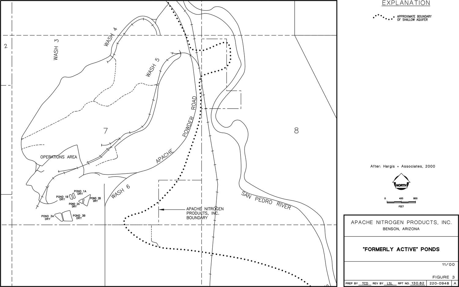
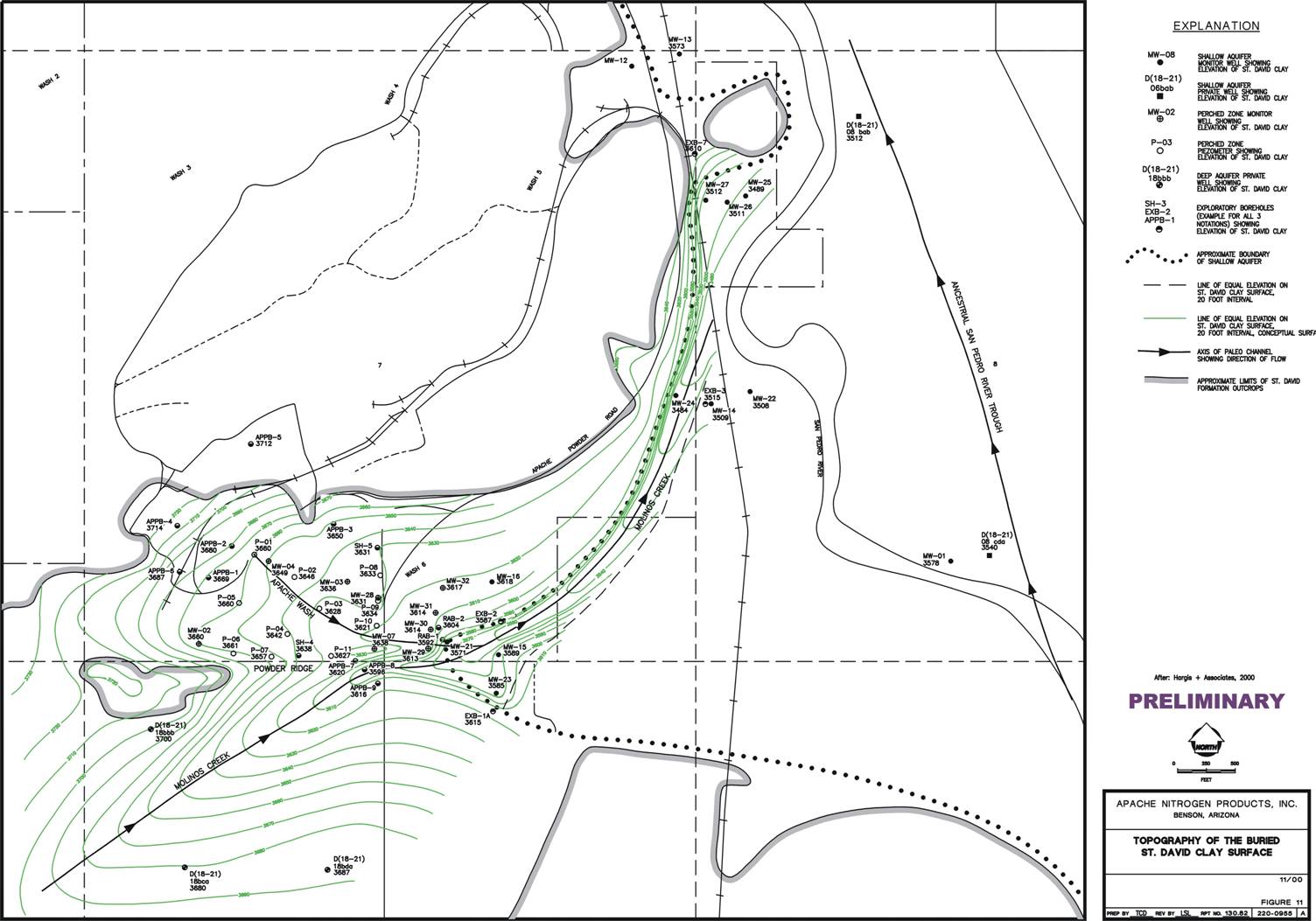
Figure 1 (see link below) shows the locations of the former wastewater percolation
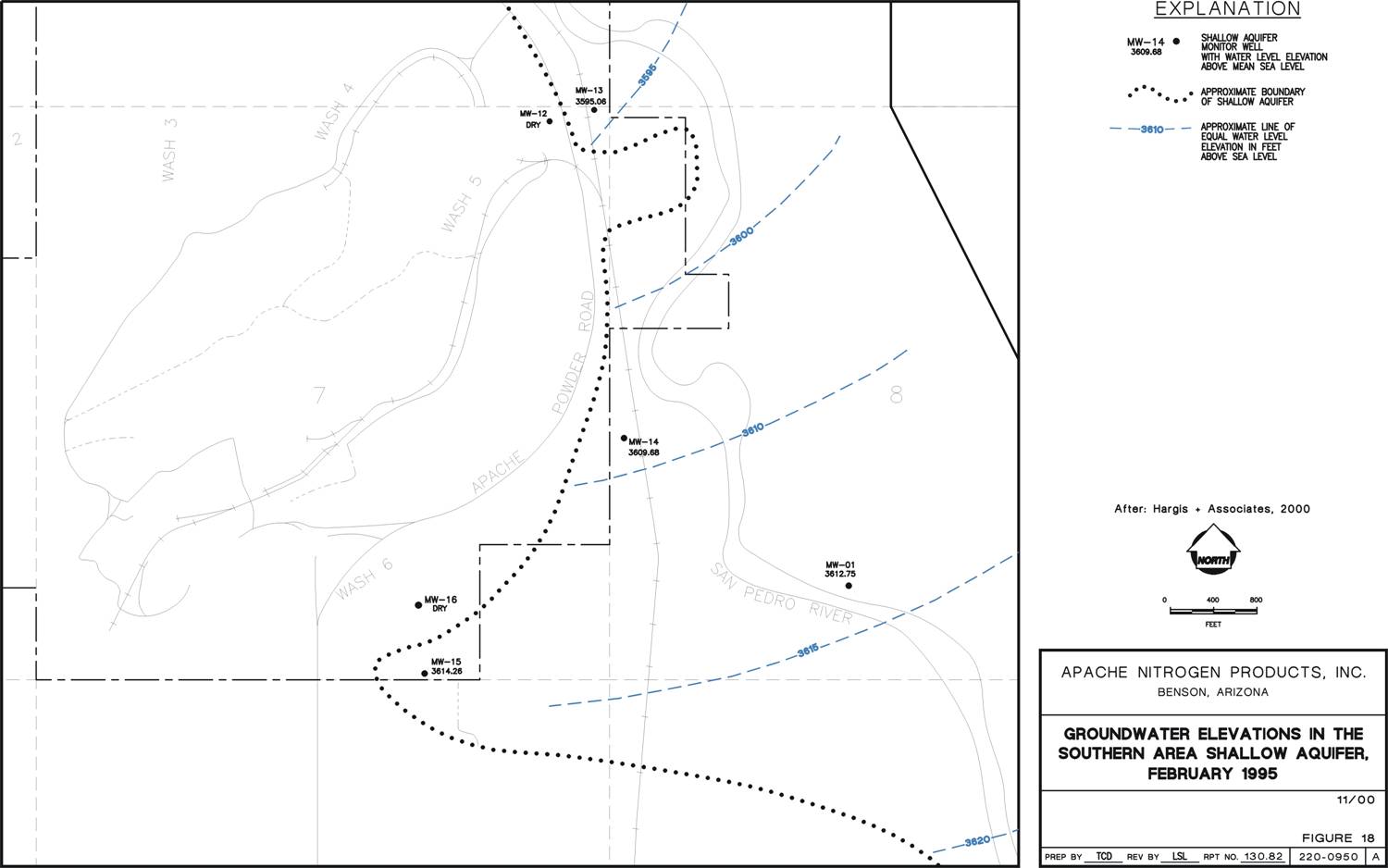
ponds. Figure 2 shows early February 1995 shallow aquifer groundwater elevations (piezometry)
prior to the cessation of wastewater discharge to the percolation ponds. For reference, the former percolation ponds
and underlying perched zone are generally located between the faint "Wash 6" and railroad
spur markings, whereas the dotted line indicates the western boundary
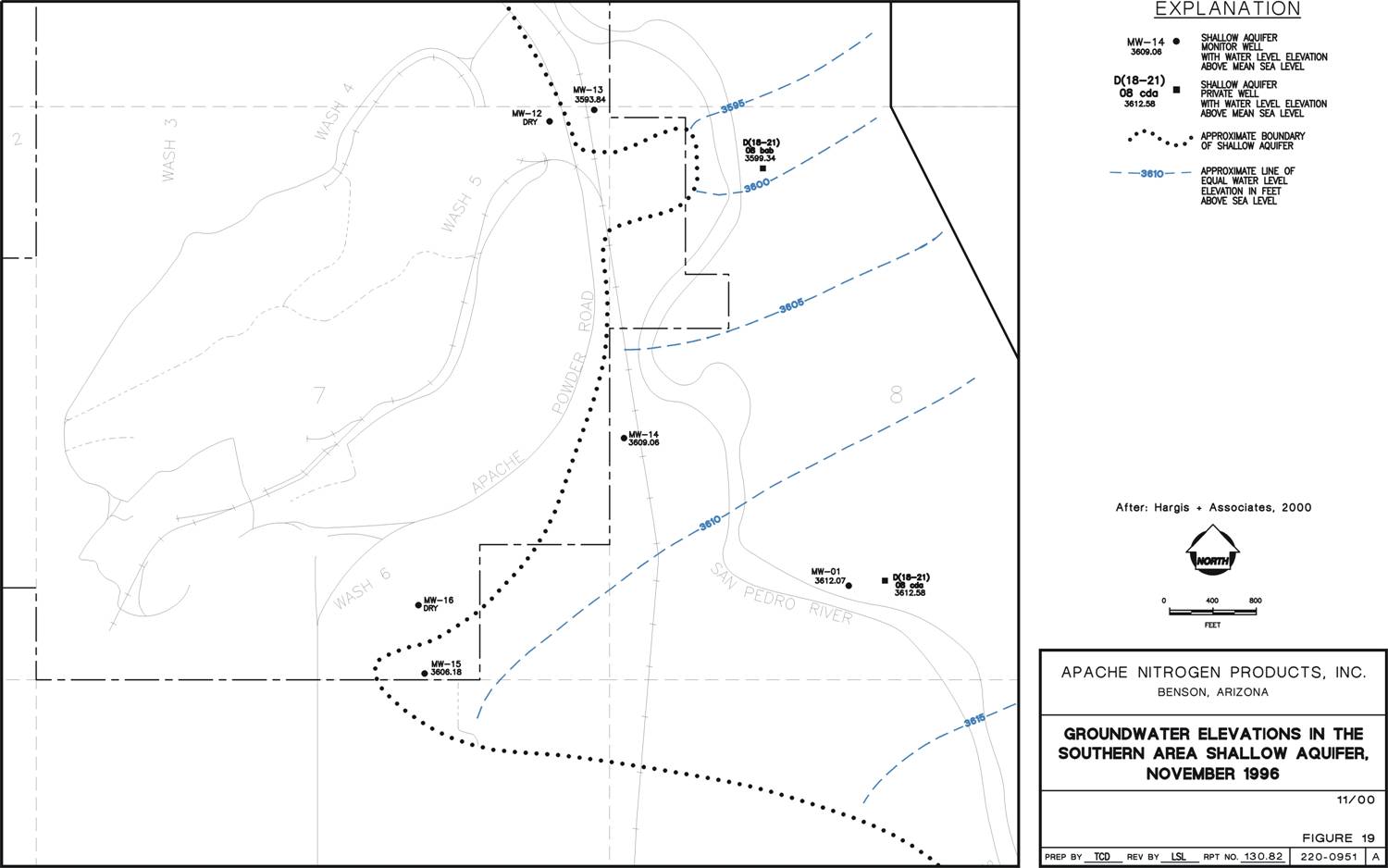
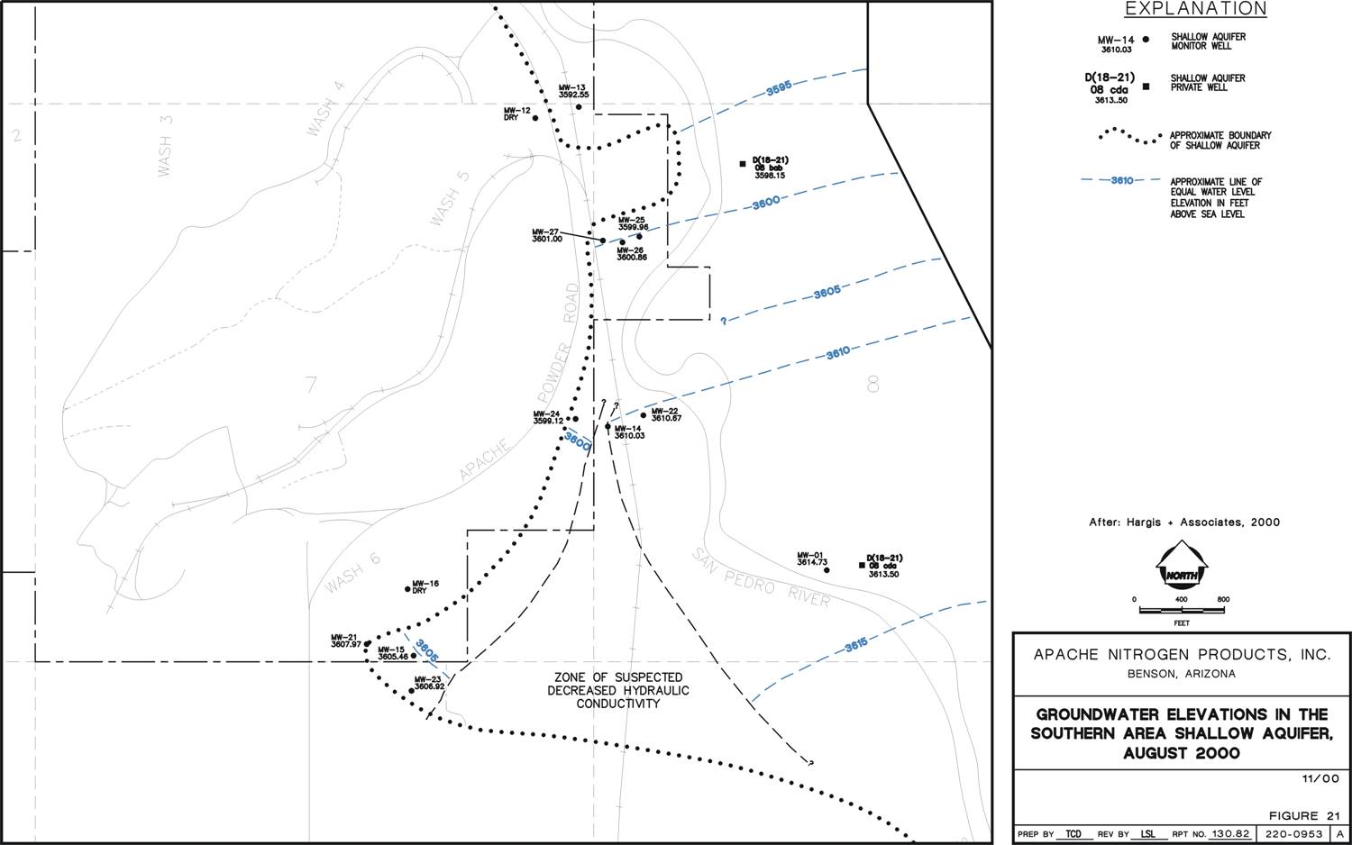
of the shallow aquifer over which the SPR flows northward. Figure 3 shows the significant piezometric
drop within the extreme western portion of the shallow aquifer
by November 1996, after cessation of wastewater discharge to the percolation ponds during late
February 1995, which is specifically shown in the change in the location and curvature
of the 3610-foot groundwater elevation line within this portion of the shallow
aquifer. The southwest bend in this line indicates that artifical groundwater recharge to this portion
of the shallow aquifer had occurred via past wastewater discharge to the percolation
ponds, followed by eastward outflow of percolated wastewater (now
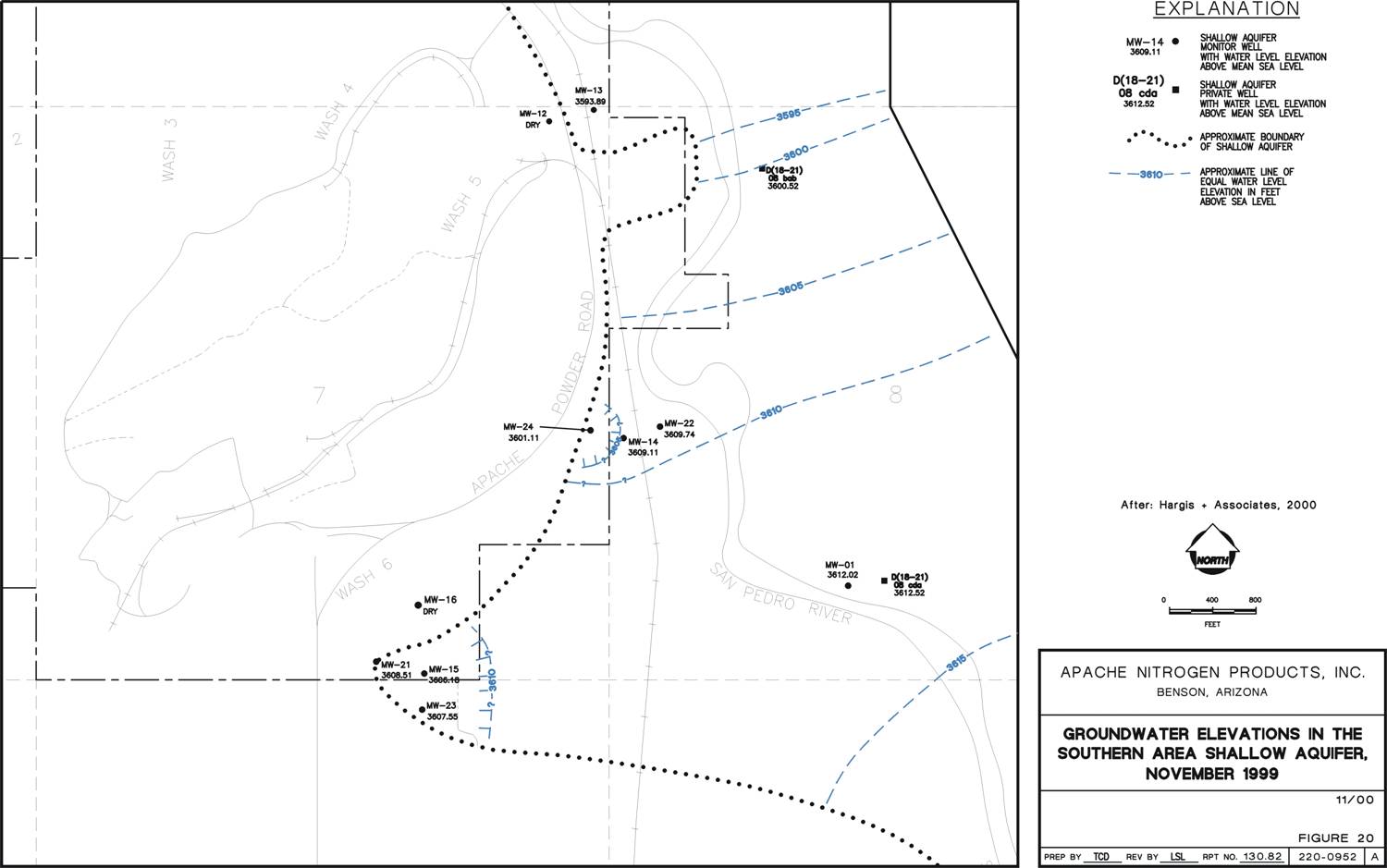
perched zone groundwater) via the perched zone paleochannels to the shallow aquifer. By November 1999, the piezometric surface of the extreme western portion
of the shallow aquifer continued to drop significantly, resulting in the appearance of unexpected piezometric surface "depression" within the shallow aquifer adjacent to the perched
zone (Figure 4). At that time, these apparent depressions could not be explained by pumping
wells or other common activites.
As part of my MS thesis while
working at Hargis+Associates, Inc. in Tucson AZ, I reviewed the logs of numerous soil borings and groundwater
monitoring wells that had been drilled through the shallow aquifer and perched zone into the underlying
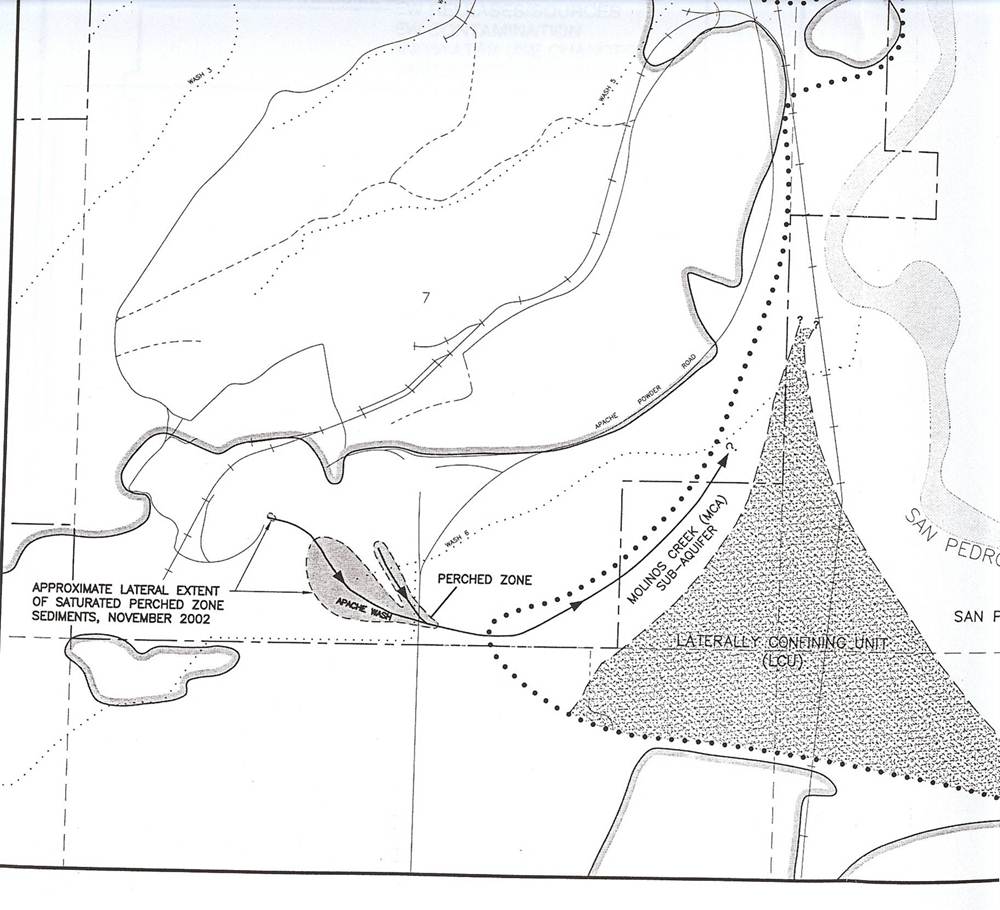
SDC. Using observed local surface outcrops of the SDC, I re-worked the local topography of the underlying SDC and theorized that previously unforeseen paleochannels had been eroded into the SDC underlying both the perched zone ("Apache Wash") and the western portion of the shallow aquifer
("Molinos Creek") (Figure 5). A raised portion of the SDC topographic surface was indicated to exist between
the Molinos Creek paleochannel and the much larger ancestral SPR paleochannel
to the east (not shown).
Using my knowledge of sedimentary geology,
I further theorized that fine-grained lateral accretions had been deposited on the raised portion of the SDC topographic surface
between the Molinos Creek and ancestral SPR paleochannels during paleohistorical flood stages, while sands and gravels had
been deposited at the same time within the paleochannels, forming the separated portions of the shallow aquifer. Deposition
of the lateral accretions formed a "lateral aquitard", initially named the "Zone of Suspected Decreased Hydraulic
Conductivity" (Figure 6). This feature was later re-named the "Laterally Confining Unit" (LCU) in the final
version of the thesis and subsequent project documents that were submitted to USEPA Region 9 (Figure 7).
The LCU significantly reduced lateral groundwater recharge from the main portion of the shallow aquifer to the narrow, smaller
"Molinos Creek Sub-Aquifer" which forms the western portion of the greater shallow aquifer, east of and adjacent
to APN. In addition, groundwater flow from the perched zone to the Molinos Creek Sub-Aquifer
occurred via the Apache Wash (Figure 7).
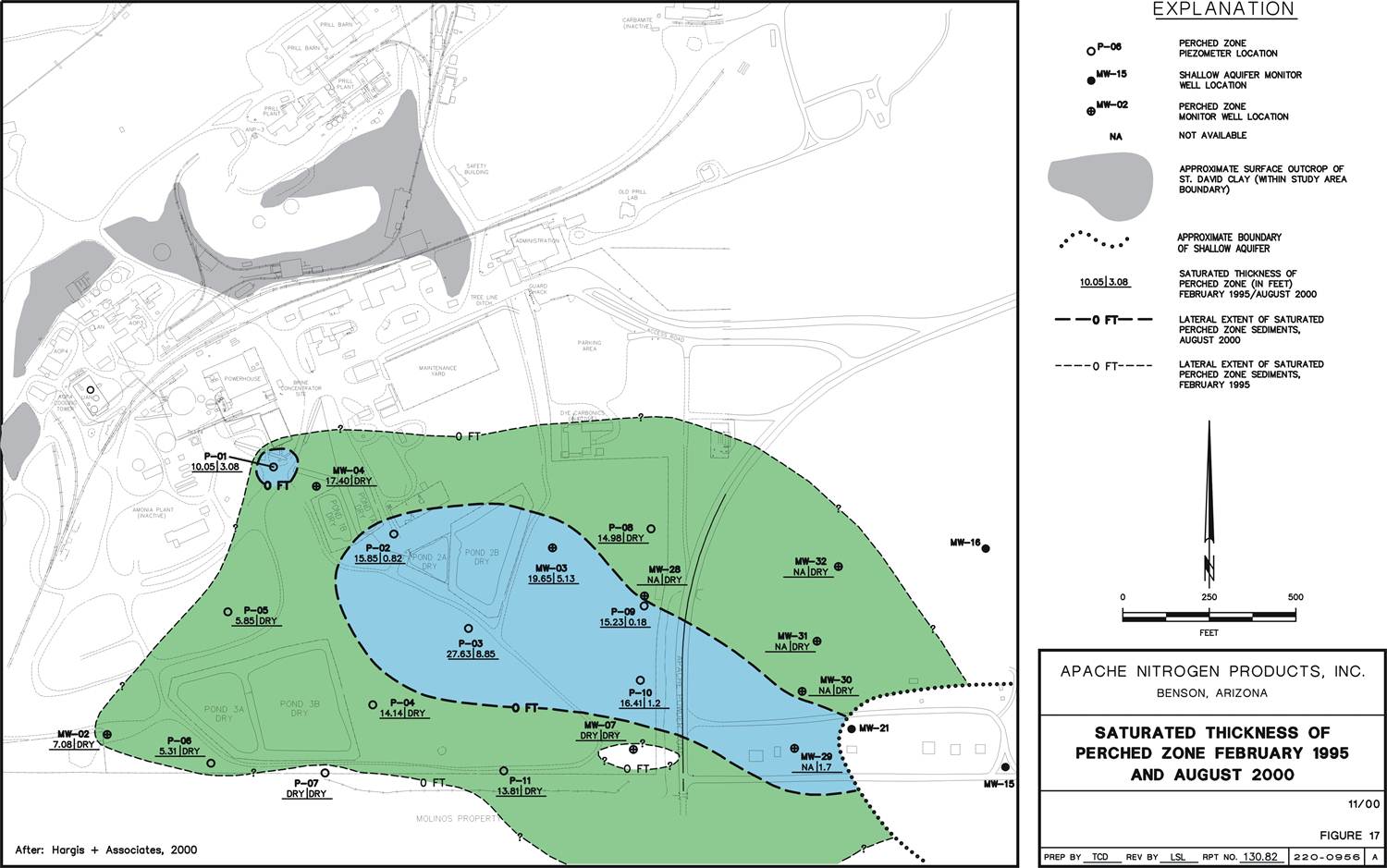
Thus, when
wastewater discharge to the percolation ponds ceased, groundwater recharge to the Molinos Creek Sub-Aquifer via the buried
perched zone paleochannels that had been eroded into the SDC essentially ceased soon after. This resulted in the closed piezometric
"depressions" previously shown on Figure 3 within the Molinos Creek Sub-Aquifer paleochannel, as well as the
significant reduction of the thickness and lateral extent of perched zone groundwater
between February 1995 (larger green area) and August 2000 (smaller blue area)
as shown on Figure 8. The LCU allows the hydraulic separation of piezometric
data within the two new portions of the shallow aquifer as shown on Figure 6. This theory
is supported by long-term hydrographs of the wells installed within the perched zone, Molinos
Creek Sub-Aquifer, and the greater shallow aquifer, as well as hydrochemical
data, all of which were included within the final version of the MSc Thesis. Subsequent
exploratory borehole drilling required by EPA Region 9 confirmed the presence of the LCU, confirming the theory as fact.
A secondary benefit of the LCU is the apparent lateral
confinement of the perchlorate/nitrate groundwater contaminant plume extending from the perched zone into the shallow aquifer.
Instead of extending outward into the greater shallow aquifer to an unknown distance as previously believed, the plume appears
to be laterally confined within the relatively narrow Molinos Creek Sub-Aquifer, which may translate into significant remediation
cost and time savings.
FIGURE 1
FIGURE 2
FIGURE 3
FIGURE 4
FIGURE 5
FIGURE 6
FIGURE 7
FIGURE 8
RESULT:
The "narrowing" of the nitrate/perchlorate plume along the western boundary of the Shallow Aquifer allowed the client
to consider remedial measures that may require a smaller number and array of wells, thus potentially reducing long-term O&M
costs. Associated document produced by me on this project: Conceptualization of Groundwater Flow
in the Shallow Aquifer Along the Apache Reach of the San Pedro River, Cochise County, Arizona (2000; University of Arizona
MSc Thesis) I appreciate the opportunity to have worked
with Dr. Leo Leonhart PhD and the staff of Hargis+Associates, Inc., Tucson AZ, while developing my MSc
thesis.
|
|
|
 |
|  |
|
| |
|
 |
 |
|


