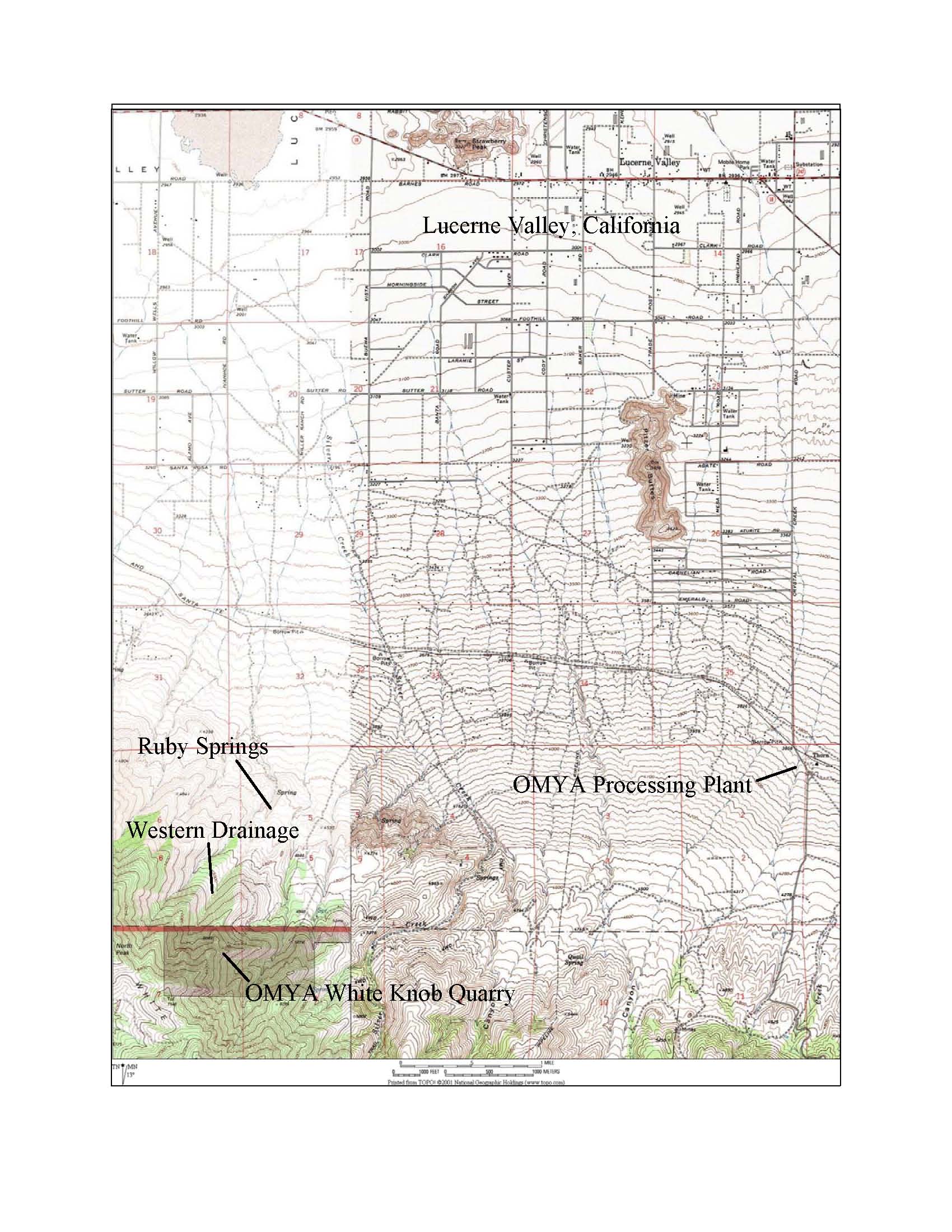
During August 2003 an intense 40-minute monsoon-type storm event occurred at OMYA’s White Knob
Quarry in Lucerne Valley CA (Figure 1), resulting in a debris flow that flowed from a combined natural/man-made talus slope
through the Ruby Springs area of OMYA’s Western Drainage. The California Department of Fish and Game claimed that
approximately 1.8 miles of the drainage were damaged via scouring of vegetation and native soils. A 2005 DCI initial
field investigation determined that only the uppermost 1.2 miles of the drainage had been scoured, whereas the remaining lower
portion of the drainage below a confluence with a “twin” drainage to the west received only a relatively watery
discharge.
Using the (Chezy-Manning
equation) estimated water fraction peak flow discharge rate of approximately 1,120 ft3/s with the Rational Method,
approximately 5.5 inches of precipitation were estimated to have occurred during the storm event. The storm event appears
to have been comparable to a 100-Year/6-Hour statistical storm event (1986 San Bernardino County Hydrology Manual) and the
following 2004 NOAA Atlas 14 statistical storm events: 1,000-Year/6-Hour, 500-Year/6-Hour, 50-Year/12-Hour, 10-Year/24-Hour,
5-Year/48-Hour, 2-Year/7-Day, and 1-Year/20-Day, indicating a highly unusual storm intensity.
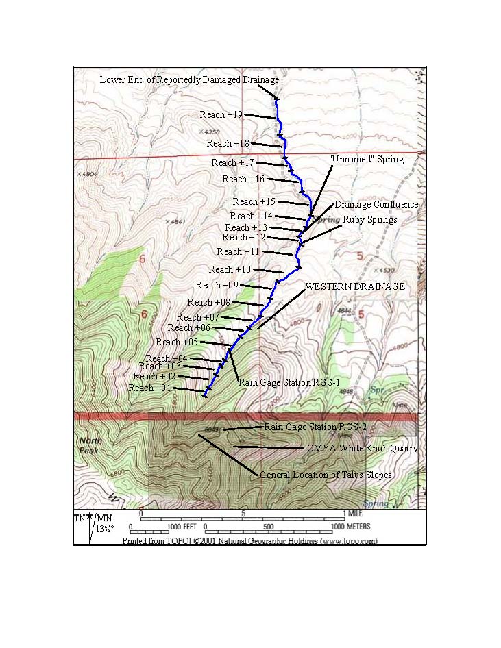
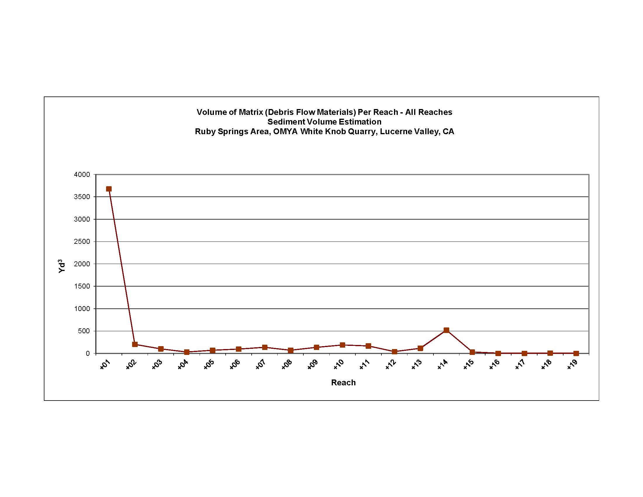
Via the use of 52 trenches distributed throughout 19 drainage reaches (Figure 2), ~341
yd3 of native soils had been eroded by the debris flow within the steeper upper reaches, and ~6,512 yd3
of debris flow materials (eroded native soils, talus slope clasts) had been deposited throughout the upper reaches (from the
toe of the talus slope down to the confluence reach), with the majority being deposited within the uppermost reach (~4,362
yd3) and the confluence reach (~519 yd3) (Figure 3).
In accordance with a 2008 DCI technical work plan, baseline and interim cross-channel
topographic data were collected at 49 of the trench locations to estimate annual rates/volumes of erosion/sedimentation of
native soils and debris flow materials (“matrix”), along with post-storm event precipitation data and Ruby Springs
discharge rate/surface flow distances, for the 2008-2009, 2009-2010, 2011-2012, 2012-2013, 2013-2014, 2014-2015, 2015-2016,
and 2016-2017 rain years (Reporting Periods). To date, native soil annual erosion/sedimentation rates have ranged
between -10 mm/yr (erosion) and +18 mm/yr (sedimentation), whereas matrix annual erosion/sedimentation rates have ranged
between -16 mm/yr (erosion) and +32 mm/yr (sedimentation). Western Drainage and nearby CIMIS station precipitation data indicate
what appears to be a temporary change in the local rain microclimate precipitation pattern during the 2012-2013 and 2013-2014
Reporting Periods, and Western Drainage precipitation data as snow (%) indicate what appears to be also a temporary change
in the local snow microclimate precipitation pattern during the 2013-2014 and 2014-2015 Reporting Periods, independent of
OMYA site activities.
Ruby
Springs discharge rates collected by DCI since 2007 indicate a virtually immediate response to the 2009-2010 Reporting Period
change from drought to wet conditions and an approximate two-year delayed response to the 2011-2012 Reporting Period change
from wet to drought conditions (Figure 4). Furthermore, a series of seasonal short-duration cycles of Ruby Springs discharge
rates has been superimposed onto an underlying long-duration cycle of Ruby Springs discharge rates. The short-duration
cycles appear to represent relatively immediate responses to storm event precipitation occurring near to Ruby Springs.
However, the long-duration cycle appears to represent the delayed response to storm event precipitation occurring within the
upper portion of the Western Drainage watershed, farther away from Ruby Springs, as a function of the cyclical cumulative
effects of multi-year drought conditions, followed by multi-year wet precipitation conditions, and then followed by the current
multi-year drought conditions.
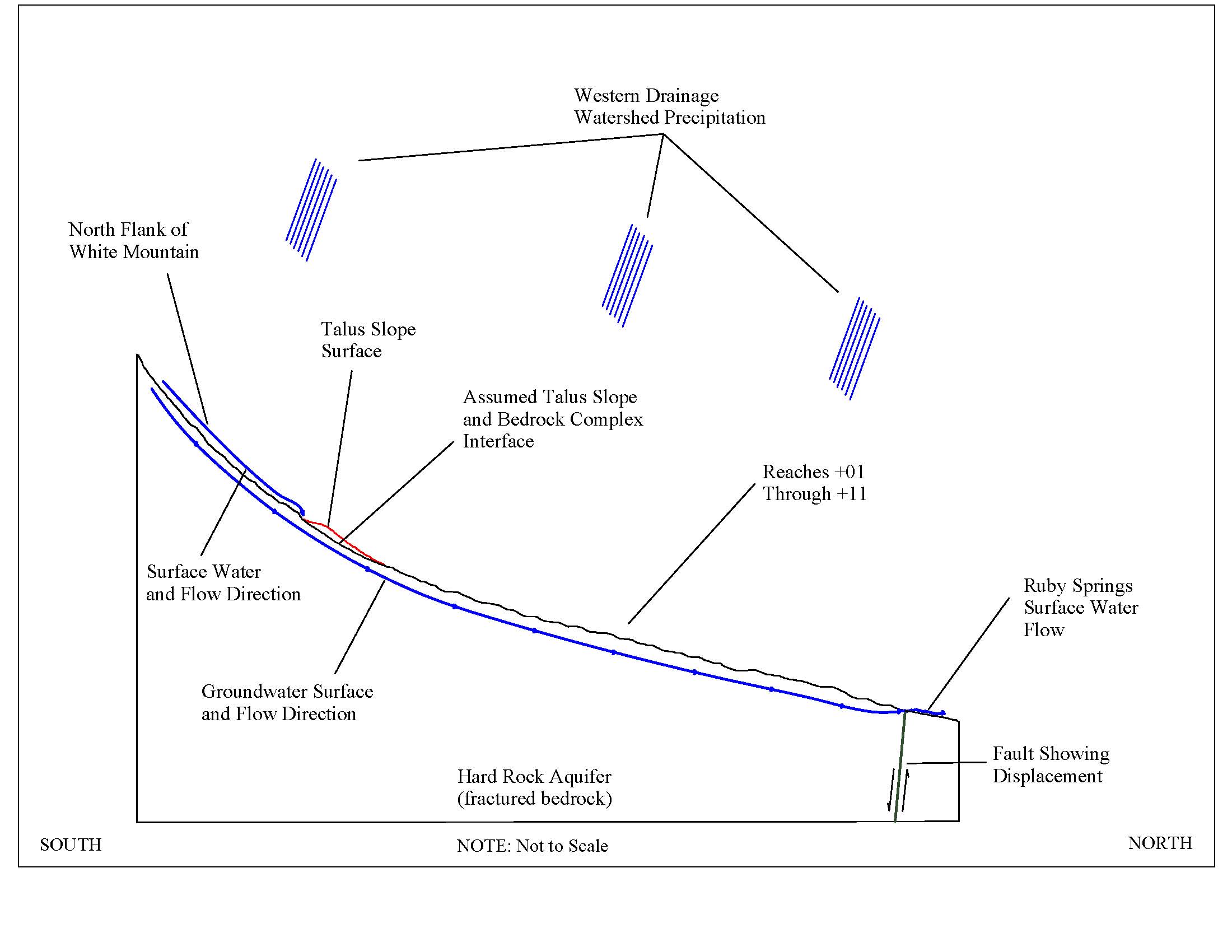
A
non-numerical conceptual groundwater model (Figure 5) was developed to explain the simple cause (precipitation) and effect
(spring discharge rates) hydrogeological scenario within the Western Drainage. Precipitation occurs as rain and/or snow, typically
during November to April, with monsoonal rains during the summer. Most precipitation appears to percolate directly in
the fractured bedrock complex that underlies the Western Drainage as "new" groundwater, with the remainder being
either evaporated (rain) or sublmimated (snow). Groundwater flows downward through the fractured bedrock aquifer toward
Lucerne Valley, via classic "rangefront" recharge of the Lucerne Valley aquifer system. Subparallel NW/SE-trending
reverse faults that cross the confluence area intercept fracture flow groundwater, forcing groundwater upward to the ground
surface, creating Ruby Spring and the nearby down-channel "Unnamed" Spring.
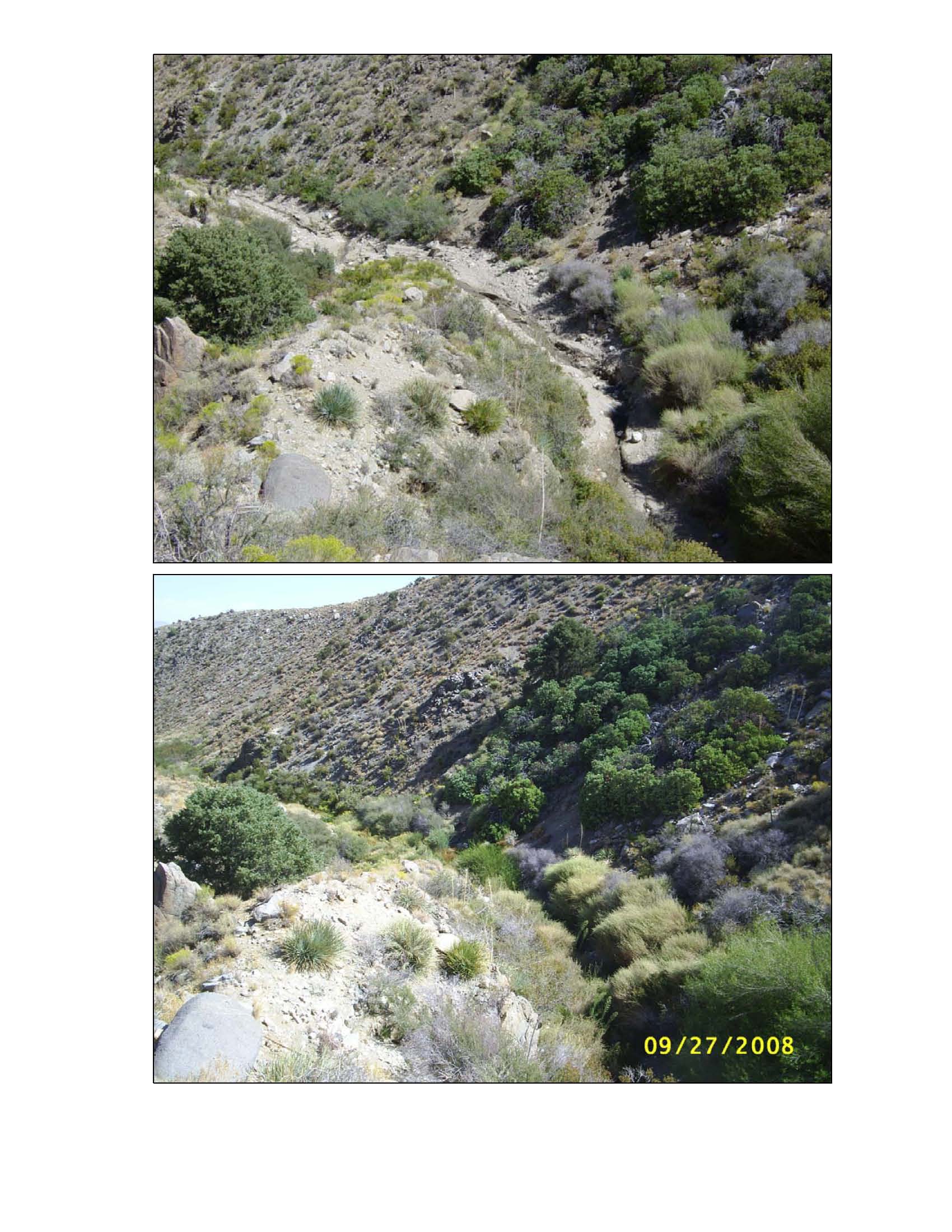
Finally,
a series of annual photos were taken by DCI during 2005-2009, at the same locations and perspectives as those taken by CDFG
during its 2003 post-storm event investigation. Photo locations included the talus slope, reaches above/below the springs
area, Ruby Springs, and the "Unnamed" Spring. All locations, especially those of Ruby Springs and the "Unnamed"
Spring, demostrated robust vegetation rebound by 2008, approximately five years after the scouring that resulted from the
August 2003 storm event. Figures 6 and 7 show vegetation rebound within the Ruby Springs and "Unnamed" Spring
areas, respectively. The upper photo of each figure was taken by CDFG during August 2003 and the lower photo of each
figure was taken by DCI during September 2008.
NOTE: Figures are from latest report (2016-2017 Reporting Period) submitted to BLM via OMYA.
Associated documents produced by DCI on this project:
Site
Hydrogeologic Opinion, Ruby Springs Area, OMYA White Knob Quarry, Lucerne Valley, California (30 January 2006)
Site Historical Aspects, Ruby Springs and “Unnamed Spring”,
OMYA White Knob Quarry, Lucerne Valley, California (22 December 2006)
Site
Hydrogeologic Opinion, Ruby Springs Area, OMYA White Knob Quarry, Lucerne Valley, California – 2006 Update (4 April
2007)
Sediment Volume Estimation, Ruby Springs Area, OMYA White
Knob Quarry, Lucerne Valley, California (7 December 2007)
Site
Hydrogeologic Opinion – Ruby Springs Area, OMYA White Knob Quarry, Lucerne Valley, California – 2007 Update
(18 December 2007)
Sedimentation and Erosion Monitoring Technical Work Plan – Ruby Springs Area, OMYA White Knob Quarry, Lucerne Valley, California
(31 May 2008)
Boulder Interstitial/Step-Pool Sediment Storage – Ruby
Springs Area, OMYA White Knob Quarry, Lucerne Valley, California (30 September 2008)
Erosion Volume Estimation – Ruby Springs Area, OMYA White Knob Quarry, Lucerne Valley, California (23
October 2008)
Site Hydrogeologic Opinion – Ruby Springs Area, OMYA
White Knob Quarry, Lucerne Valley, California – 2008 Update (24 October 2008)
Response to 2003 and 2005 CDFG Documents – Ruby Springs Area, OMYA White Knob Quarry, Lucerne Valley, California
– 2008 Update (21 November 2008)
Sedimentation and Erosion Monitoring, 2008-2009
Reporting Period – Ruby Springs Area, OMYA White Knob Quarry, Lucerne Valley, California (20 August 2009)
Statistical Storm Event Estimation, August 2003 Storm Event – Ruby Springs Area, OMYA White Knob Quarry,
Lucerne Valley, California (30 September 2009)
Site Hydrogeologic
Opinion – Ruby Springs Area, OMYA White Knob Quarry, Lucerne Valley, California – 2009 Update (17 December
2009)
Revised Statistical Storm Event Estimation, August 2003 Storm
Event – Ruby Springs Area, OMYA White Knob Quarry, Lucerne Valley, California (22 July 2010)
Sedimentation and Erosion Monitoring, 2009-2010 Reporting Period – Ruby Springs Area, OMYA White Knob Quarry,
Lucerne Valley, California (23 July 2010)
Talus Slope Impact
on Ruby Springs – Western Drainage, OMYA White Knob Quarry, Lucerne Valley, California (15 September 2011)
Sedimentation and Erosion Monitoring, 2011-2012 Reporting Period – Ruby Springs Area, OMYA White Knob Quarry,
Lucerne Valley, California (13 September 2013)
Sedimentation
and Erosion Monitoring, 2012-2013 Reporting Period – Ruby Springs Area, OMYA White Knob Quarry, Lucerne Valley, California
(14 September 2013)
Sedimentation and Erosion Monitoring, 2013-2014
Reporting Period – Ruby Springs Area, OMYA White Knob Quarry, Lucerne Valley, California (9 February 2015)
Sedimentation and Erosion Monitoring, 2014-2015 Reporting
Period – Ruby Springs Area, OMYA White Knob Quarry, Lucerne Valley, California (17 January 2016)
Sedimentation and Erosion
Monitoring, 2015-2016 Reporting Period – Ruby Springs Area, OMYA White Knob Quarry, Lucerne Valley,
California (22 August 2016)
Sedimentation and Erosion Monitoring, 2016-2017 Reporting Period – Ruby Springs
Area, OMYA White Knob Quarry, Lucerne Valley, California (14 August 2017)
I appreciate the opportunity to have worked with Mr. Howard Brown, Mr. Peter Sutherland, Mr. David Harp,
and Ms. Shelby Olsen of OMYA, Inc., and Mr. George Webber of Webber & Webber Mining Consultants, Inc. on the OMYA project.


